
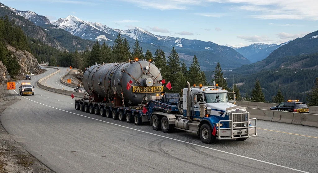
Heavy haul trucking transforms an ordinary road journey into a coordinated engineering and logistics operation. When a load exceeds standard limits for weight, height, width, or length, a route that appears open on a map may still contain a bridge with insufficient clearance, a narrow turn, or a roadway unable to support the vehicle’s axle loads. Route surveys help identify these constraints before departure, while permits, engineering reviews, and coordination with infrastructure authorities determine how the movement can proceed safely.
Route Surveys for Heavy Haul Trucking
A heavy-haul survey examines the planned journey as a sequence of physical constraints, not simply as a line between two locations. Survey teams compare vehicle and load dimensions with roadway geometry, overhead clearances, bridge information, and current traffic conditions.
Survey Measurements and Field Verification
Mapping data provides a starting point, but field checks can reveal details that digital records miss. Crews may measure bridge openings, inspect turning space at intersections, assess road shoulders, and note temporary features such as construction barriers or utility lines.
Vehicle Dimensions and Load Configuration
The required route depends on the complete transport configuration, including the trailer, load position, axle arrangement, and any permitted adjustments to suspension or steering. A few centimetres of additional height can change which structures are passable, while a long combination vehicle may need significantly more room to turn.
That is why survey findings should be checked against the final equipment configuration rather than preliminary dimensions. Accurate measurements are the foundation of a defensible route plan.
Infrastructure Restrictions Along the Route
Once the vehicle profile is established, planners assess the structures and road features that could limit movement. Restrictions vary by location and may depend on posted limits, engineering records, condition inspections, or temporary changes to the roadway.
Bridge Capacity and Axle Loads
Bridge suitability depends on more than the total gross weight. Engineers may consider axle spacing, concentrated loads, vehicle speed, and the bridge’s structural condition; a movement that meets a general weight limit may still require a specific assessment.
When records indicate a concern, the route may need a different crossing, a controlled speed, revised axle spacing, or a prescribed travel position. Bridge approval must reflect the actual load configuration and the authority’s requirements.
Clearance, Turns, and Road Conditions
Overhead structures—including signs, cables, and railway equipment—can restrict tall loads, while narrow lanes, roundabouts, and tight intersections challenge long or wide combinations. Steep grades, weak shoulders, low-bearing roads, and seasonal conditions may also affect access.
Planners should distinguish permanent obstacles from temporary ones. Roadworks, parked vehicles, and changed traffic controls can make a previously surveyed path unsuitable, so the plan needs a process for checking conditions close to departure.
Permits and Route Planning Controls
Permitting requirements differ among jurisdictions, and an authorization for one road or time window does not automatically cover another. Applications commonly rely on accurate vehicle dimensions, weight distribution, proposed roads, and supporting engineering information.
A practical planning review should confirm the following before dispatch:
- Route authorization: verify permitted roads, travel dates, operating hours, and any escort conditions.
- Structure requirements: confirm bridge assessments, clearance checks, and any specified crossing procedure.
- Movement controls: identify traffic management, utility coordination, road closures, or required notices.
- Contingency arrangements: establish who can approve a diversion and how revised conditions will be checked.
These controls connect the survey to the real-world movement. A route that is technically passable may still be unusable if a permit condition, local restriction, or coordination requirement has been overlooked.
Risk Management for Heavy Haul Movements
Even a carefully surveyed route can change between inspection and travel. Weather, construction, incidents, and revised access rules may alter the safe operating conditions, making communication and decision authority part of the route plan.
A concise route document should identify known constraints, approved alternatives, inspection responsibilities, and escalation contacts. Dispatchers, drivers, escorts, surveyors, and relevant authorities need access to the same current information; otherwise, a change made by one party may not reach the others in time.
| Restriction | Potential Impact | Planning Response |
|---|---|---|
| Bridge capacity | Structural loading may exceed assessed limits. | Obtain engineering review and follow approved crossing conditions. |
| Overhead clearance | The load may strike a bridge, cable, or sign. | Verify clearances against the complete vehicle configuration. |
| Turn geometry | The trailer may encroach on opposing lanes or obstacles. | Survey swept paths and arrange traffic controls where required. |
| Temporary works | Barriers or closures may block the approved route. | Recheck conditions and use only an authorized alternative. |
Clear documentation also supports consistent decisions when conditions change. For complex movements, specialist surveyors and transport engineers can interpret infrastructure data, coordinate approvals, and recommend controls suited to the specific load.
Operational Readiness for Restricted Routes
Before departure, the final route should be checked against the actual truck, trailer, and load, with permits and operational instructions available to the people responsible for the move. Where a restriction cannot be verified or safely managed, the movement should pause until the route or controls are revised.
Effective heavy-haul planning brings together field measurements, infrastructure assessments, regulatory approvals, and active communication. Consulting qualified route-survey professionals helps ensure that specialized advice and any required intervention reflect the specific journey.


